
Parkville is a city in Platte County, Missouri, United States and is a part of the Kansas City Metropolitan Area. The population was 7,177 at the 2020 census. Parkville is known for its antique shops, art galleries, and historic downtown. The city is home to Park University, English Landing Park, Platte Landing Park, and the National Golf Club of Kansas City. Large neighborhoods in Parkville include: Riss Lake, The National, Thousand Oaks, Creekside, Parkville Heights, River Hills, Riverchase, The Bluffs, Downtown, and Pinecrest.
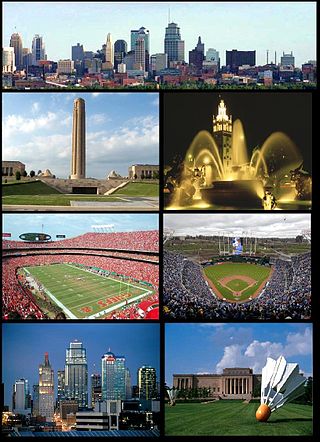
The Kansas City metropolitan area is a bi-state metropolitan area anchored by Kansas City, Missouri. Its 14 counties straddle the border between the U.S. states of Missouri and Kansas. With 8,472 square miles (21,940 km2) and a population of more than 2.2 million people, it is the second-largest metropolitan area centered in Missouri and is the largest metropolitan area in Kansas, though Wichita is the largest metropolitan area centered in Kansas. Alongside Kansas City, Missouri, these are the suburbs with populations above 100,000: Overland Park, Kansas; Kansas City, Kansas; Olathe, Kansas; Independence, Missouri; and Lee's Summit, Missouri.

Dr. John Alexander Low Waddell was a Canadian-American civil engineer and prolific bridge designer, with more than a thousand structures to his credit in the United States, Canada, as well as Mexico, Russia, China, Japan, and New Zealand. Waddell’s work set standards for elevated railroad systems and helped develop materials suitable for large span bridges. His most important contribution was the development of the steam-powered high-lift bridge. Waddell was a widely respected writer on bridge design and engineering theory, as well as an advocate for quality in higher education engineering programs. The company he founded in 1887, 'J.A.L. Waddell, Consulting Engineer,' would eventually become the modern day Hardesty & Hanover, a leading moveable bridge engineering firm. Many of Waddell's surviving bridges are now considered historic landmarks.
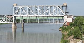
The Armour-Swift-Burlington (ASB) Bridge, also known as the North Kansas City Bridge and the LRC Bridge, is a rail crossing over the Missouri River in Kansas City, Missouri, that formerly also had an upper deck for automobile traffic.

The Chouteau Bridge a four-lane girder bridge on Route 269 across the Missouri River between Jackson County, Missouri, and Clay County, Missouri. The bridge is named for Francois Chouteau, who was a member of the Chouteau fur trapping family and is considered the first permanent settler in Kansas City.

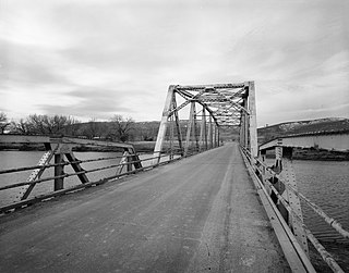
English Landing Park is located along the Missouri river in Parkville, Missouri, United States. The area the park now sits were once just low water areas of the Missouri River. It includes a 3-mile jogging/biking trail that follows the river's edge, several shelters for picnics, a soccer field, a baseball diamond, volleyball courts, 2 playgrounds. Recently, a small 9-hole Frisbee golf course has been added around the jogging/biking trail. There is also a busy set of train tracks that runs along the length of the park. The area of present-day English Landing Park was bought from the English Brothers by Colonel George S. Park in 1838, who was a veteran of the Texas war of independence. He purchased a riverboat landing from them as well, and that riverboat landing as well as the present-day park became a civil war port of call for slave trade. The Riverpark Pub and Eatery, which sits right next to the rail road tracks at the entrance to the park, was built in the mid-19th century as a coal-fired twin-boiler power plant that fed the entire city. The city itself was founded by Colonel Park in 1844 and by 1850 he had built warehouses and a large stone hotel. In 1853 he established one of Platte County's earliest newspapers, The Industrial Luminary. Parkville itself did not become a Civil War battlefield, but there was still mass genocide as numerous slaves tried desperately to escape across the river into Kansas for freedom. These slaves were buried in three large but unmarked cemeteries in the present-day Misty Woods subdivision. After the Civil War, the port and the riverboat landing were all but abandoned and the area slowly changed from a bustling port city to what is present-day Parkville.

The Bellefontaine Bridge is a four-span truss railroad bridge over the Missouri River between St. Charles County, Missouri, and St. Louis County, Missouri. It has four 440-foot (130 m) spans. Construction started on July 4, 1892, and the bridge opened on December 27, 1893.

The 19th Street Bridge is a two-span through Pratt truss road bridge in Denver, Colorado, over the South Platte River, now used for pedestrians. It was built in 1888 to replace a wooden structure and carried automobile traffic until 1986. The bridge is listed on the National Register of Historic Places.

The Linden Street Bridge is a historic bridge on the abandoned Central Massachusetts Railroad over Linden Street in Waltham, Massachusetts. It is a riveted lattice through truss bridge, built in 1894 by the Pennsylvania Steel Company, and is one of only three such bridges left in the state. The bridge is 98 feet 3 inches (29.95 m) long and 17 feet (5.2 m) wide, with an inside truss height of 21 feet 11.5 inches (6.693 m), and rests on granite abutments. The design of the bridge was based on that of the Northampton crossing of the Connecticut River by the same railroad. This section of the Central Massachusetts Branch, and the bridge, have been out of service since the early 1990s when service to the last customer, a lumber dealer located on Emerson Road, ended.
The Kansas City Southern Railroad Bridge (Cross Bayou), in downtown Shreveport, Louisiana, is an "A" Truss bridge erected in its current location in 1926 and abandoned in the 1980s. Due to its national significance to the progress of American bridge design, and its rarity as one of only two known surviving examples, the structure was designated a National Historic Place in 1995.
The Keystone Bridge Company, founded in 1865 by Andrew Carnegie, was an American bridge building company. It was one of the 28 companies absorbed into the American Bridge Company in 1900. The company advertised its services for building steel, wrought iron, wooden railway and road bridges. It held a patent for wrought iron bridges and also supplied wrought iron columns for buildings. Thomas Carnegie worked for Keystone Bridge as treasurer for roughly 20 years, from the founding of the company until his death in 1886.

The Upper Paris Bridge is an historic structure located near the town of Coggon in rural Linn County, Iowa, United States. The pin-connected Whipple through truss bridge was built in 1879 as a wagon bridge. It was designed by the Wrought Iron Bridge Company of Canton, Ohio. The bridge was listed on the National Register of Historic Places in 1998 as a part of the Highway Bridges of Iowa MPS.

Waddell & Harrington was an American engineering company that designed bridges from 1907 to 1915. It was formed in 1907 as a partnership of John Alexander Low Waddell (1854–1938) and John Lyle Harrington (1868–1942) and was based in Kansas City, Missouri, but had offices in Portland, Oregon, and Vancouver, British Columbia. The company designed more than 30 vertical-lift bridges for highways and railroads.

The DMJ Pick Bridge is a Parker through truss bridge located near Saratoga, Wyoming, which carries Carbon County Road CN6-508 across the North Platte River. The bridge was built from 1909 to 1910 by contractor Charles G. Sheely; it was originally located south of Fort Steele. In 1934, the bridge was moved up the river to its current location, as a new bridge had been built at its original site five years earlier. The bridge is the only Parker truss bridge remaining in Wyoming, after the Arvada Bridge was replaced in 1990.

The DML Butler Bridge is a historic bridge over the North Platte River in Carbon County, Wyoming, United States, that is listed on the National Register of Historic Places (NRHP).
The DUX Bessemer Bend Bridge was a Warren through truss bridge in Bessemer Bend, Wyoming, which carried Natrona County Road CN1-58 across the North Platte River. The bridge was built from 1921 to 1922. When nominated to the National Register of Historic Places in 1982, it was one of only three Warren through truss bridges remaining on Wyoming county highways. In addition, the bridge was located at the site of a historic river crossing on the Oregon Trail.
The EWZ Bridge over East Channel of Laramie River is a Pratt pony truss bridge that was located near Wheatland, Wyoming, which carried Platte County Road CN8-204 over the East Channel of the Laramie River. The bridge was built from 1913 to 1914 by the Pueblo Bridge Company. The single-span bridge was 71 feet 2 inches (21.69 m) long. The bridge's five-panel Pratt pony truss design with steel pin connections was used fairly frequently in Wyoming highway bridges, and the bridge was one of the older examples of the style.

The Alton Bridge was a railroad bridge that carried the Chicago, Burlington, and Quincy across the Mississippi River between West Alton, Missouri, and Alton, Illinois. It was located 100 yards (91 m) upriver from, and parallel to, the Old Clark Bridge. The bridge was built between 1892 and 1894 and was removed shortly after the line was abandoned in 1988. With a total length of 2,060 feet (630 m), it consisted of eight through-truss segments—six Pratt trusses, one Pennsylvania truss, and one pivot-swinging truss.

The East Shoreham Covered Railroad Bridge is a historic covered bridge spanning the Lemon Fair River near East Shoreham, Vermont. Built in 1897 by the Rutland Railroad Company, it is the state's only surviving example of a wooden Howe truss railroad bridge. It was listed on the National Register of Historic Places in 1974.

The Waddell "A" Truss Bridge is standardized truss bridge design that was first patented in 1893 by prolific civil engineer John Alexander Low Waddell. The design provided a simple low-cost, high-strength solution for use by railroads across the United States and Empire of Japan for short spans of around 100 ft. According to the Historic American Engineering Record (HAER), "beyond its role in the growth of railroad transportation, the "A" truss is perhaps most historically significant when viewed within the context of Waddell's career and the emergence of the American bridge fabrication industry into international marketing."


